05/01/26 - Walking, Electrical Voice & Unearthing
- Ritchard Allaway

- Jan 7
- 7 min read
31st December
Field Research: Sutton Bank to Sneck Yate Way

The last day of 2025 and the first entry of 2026. As now somewhat of a tradition, I found myself walking on the morning of new year’s eve, possibly to think this could be my last walk of the year (like some great anomaly could occur at midnight meaning that I had one more intimate walking experience) or possibly it is a walk to consider a move towards the end or to the new (2026), or that it is a walk to reflect on the year in a subtle and relaxing wat, whatever this new year’s eve tradition is, it is here and I thoroughly enjoy (even if it was very cold as the snowy weather was heading in).
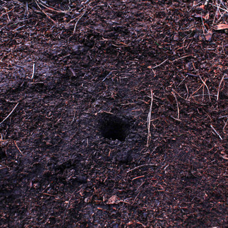
The purpose of this walk (aside from my unanswered of the year consideration), was to walk through a ‘new’ landscape, gather electrical readings from the soil and then unearth soil samples which will be used at a later date to translate soil voice. The past several months I have been considering methods on how to translate soil voice and so I have some returning methods in mind (soil chromatography and lumen prints) which have been placed into a series of design ideas for artistic output. I am hoping to complete some of these artistic output within January and February.
To support me on this walk (apart from new swanky walking boots), I took a few pieces of equipment with me which included a T-Bar soil sample tool, meter reader, cathode and anode rods, multiple sample vials (which I purchased a bag of about 50 for £6 – bargain), SLR camera, Tascam, headphones and my D.I.Y soil hearing probe. The latter I will write a blog about soon, as within this walk I did not test it out and therefore no soil sound recordings were heard or unearthed. Once the snow and ground soften I will head out again and test out this piece of equipment.

Although I described this walk as taking place within a ‘new’ landscape, it was not unfamiliar to me. I have travelled through this area on multiple occasions, and at the beginning of my PhD I walked this same stretch of land, though in the opposite, southerly direction. On this occasion, I headed north along the Cleveland Way, beginning at Sutton Bank and walking towards Sneck Yate Bank. The route formed a six-mile circular walk, taking approximately three hours to complete, not accounting for pauses to stop, read, and unearth the ground underfoot.
I have returned to the Cleveland Way several times throughout my research period. Most recently, in a blog post from April 2025, I walked sections around Osmotherley. To briefly recap, the Cleveland Way is a 109-mile long trail that runs through the North York Moors National Park, connecting Helmsley to Filey and passing through locations such as Whitby, Scarborough, and Kilburn. The terrain shifts along the route, encompassing heather moorland, peatland, and exposed escarpments.
Sutton Bank lies just south of Osmotherley, linking the latter with Helmsley. It is the highest point in the Hambleton Hills and carries the A170 road between Thirsk and Scarborough. The bank is known for its steep gradients and hairpin bend, a road that is far more enjoyable to drive down than up. Historically, Sutton Bank is rich with layered activity: the site of an Iron Age hill fort, the Battle of Old Byland in 1322 between English and Scottish forces, and later the training of German glider pilots during the 1930s. This latter use resulted in the construction of defensive trenches when war was declared in 1939, amid fears of a potential airborne landing. Due to this deep and overlapping history, the precise age of the route itself is difficult to determine, though some historians suggest prehistoric origins, supported by Bronze and Iron Age artefacts found in the area.
The morning of my walk was busy. Sutton Bank is a popular tourist destination, and the path was populated by a wide range of walkers. Accents suggested a mixture of local, regional, and international visitors, demonstrating a level of accessibility that contrasts with the isolation I often encounter during more remote walks. While the area initially lacks a sense of solitude, this shifts further along the route, as many visitors remain close to their vehicles rather than moving deeper into the landscape.
Geologically, the escarpment is formed from layers of Jurassic rock, including limestone, sandstone, and gritstone. The soils are predominantly clay-based, marked by yellowish tones alongside darker browns. Garbutt Nature Reserve lies within this stretch of the Cleveland Way and encompasses Lake Gormire, which can be viewed from Whitestone Cliff. This viewpoint was described by James Herriot as ‘the finest view in England’. The surrounding woodland supports a dense network of micro-habitats, rich in lichen, mosses, and micro-organisms. My walk concluded at Sneck Yate Bank (also known as Boltby Bank), approximately three miles north of my starting point at Sutton Bank.


I will not recount the walk in excessive descriptive detail. My intention is not to translate feelings or visual experience through language, but to allow the unearthed soil to articulate these conditions itself. This will be enacted at a later stage, as outlined earlier.
As with previous walks, the journey began seated on the edge of my car boot, lacing my walking boots. Equipment was loaded into my bag, with a small number of vials placed in my top pocket alongside a pen for labelling. The meter reader, cathode and anode probes, and the T-bar were kept to hand for ease of access, allowing readings and unearthing to occur efficiently while moving through the landscape. The morning was clear, marked by a low winter sun and cold air, which became more pronounced along exposed edges and clearings. I set off from the National Park Centre, which was busy with families, cyclists, and walkers—it was still the holiday period, New Year’s Eve.
I headed north, taking in my surroundings while exchanging repeated ‘good mornings’ with passersby and occasionally navigating around loose, excitable dogs. I began taking readings immediately from the starting point, alongside unearthing an initial soil sample. This activity drew curiosity, prompting questions such as ‘What are you looking for—gold?’ and ‘What are you doing with that?’ I am always open to discussing my work, and many of these exchanges were met with genuine interest; a few people appeared to assume I was working on behalf of the Moors Trust.
Initial readings registered at 0.820 volts, indicating micro-activity within the soil system. While this did not suggest heightened vitality, it nevertheless evidenced an active underground environment approaching one volt. Throughout the walk, the majority of readings remained within the 0.8 range. When calculated across all recorded positions (see below), this produced an average reading of 0.8431 volts, with the highest reading at 0.946 and the lowest at 0.766. These readings point towards lively soil systems; however, given the landscape’s sandstone and clay composition, nutrient availability and vitality appeared moderate to low. As expected, the highest reading was recorded within areas of moss and lichen, where nutrient density is greater and soil micro-activity is consistently more pronounced.
P1 - 0.820
P2 - 0.867
P3 - 0.842
P4 - 0.817
P5 - 0.796
P6 - 0.946
P7 - 0.766
P8 - 0.855
P9 - 0.860
P10 - 0.862


The path alternated between dry and wet ground, carrying me through multiple terrains along the Cleveland Way and towards what has been described as ‘the finest view in England’. Along the route, I engaged with the language of the landscape through way markers and navigation points that guide walkers across the escarpment. At one such point, I paused briefly to help a family take a photograph as they posed together, an incidental but telling reminder of the shared social rhythms that exist alongside solitary walking practices.
Leaving the main route, I entered Garbutt Nature Reserve, stepping carefully down a rocky path to explore what forms of activity were present beneath the surface. After unearthing and recording, I climbed back up and looked out across Lake Gormire, a view that was expansive and quietly absorbing. To my left, the land opened out towards what felt like home; somewhere in the far distance to the north I could faintly make out the industrial edge of the North East. Clouds began to draw in and the cold winter air intensified. The elements were pressing against the body, but the sensation was sharp and invigorating rather than hostile.
The landscape shifted again as I entered a small stand of trees dominated by tall pines. Here, traces of human intervention appeared in the form of foraged foliage and bent branches, shaped into small shelters, temporary, sculptural gestures embedded within the woodland. Fern and bracken followed, broken up by man-made stone boundaries. Gradually, the presence of other walkers diminished as I continued towards Sneck Yate Bank. The walk became more isolated and intimate, a transition I welcomed. While I do not oppose the presence of others, human voices tend to dominate; as these faded, the sounds of wind, movement, and ground underfoot became the dominant register.
At this stage, I had intended to use my sound probe but chose instead to focus solely on unearthing soil samples. This decision felt appropriate and aligned with the rhythm of the walk, with sound to be returned to at a later date. By the time I reached Sneck Yate Bank, I had collected ten samples and corresponding readings, which felt sufficient given the conditions. I would have liked to gather more, but the weather was changing rapidly, and the winter elements were beginning to take their toll on my body. The day had moved more quickly than anticipated, and I decided to retrace my steps.
The return walk was undertaken without further sampling or readings. Instead, I allowed myself to move back through the landscape attentively, reviewing what had been traversed and engaging only with the rhythm of bodily movement through and within the terrain.


Reference list
Author Unknown (2007). The history of Sutton Bank - always a popular place to be. [online] Darlington and Stockton Times. Available at: https://www.darlingtonandstocktontimes.co.uk/news/1789051.the-history-of-sutton-bank-always-a-popular-place-to-be/ [Accessed 7 Jan. 2026].
Brown, M. (2024). North Yorkshire landmark has ‘finest view’ – but did it also have a Nazi spy? [online] the Guardian. Available at: https://www.theguardian.com/uk-news/article/2024/jun/14/north-yorkshire-landmark-nazi-spy-sutton-bank-project-history [Accessed 5 Jan. 2026].
Russell, R. (2024). Sutton Bank: Iron Age and Nazi history of landmark to be explored. BBC News. [online] 28 May. Available at: https://www.bbc.co.uk/news/articles/crgg2p1nve2o [Accessed 5 Jan. 2026].
Unknown Author (2026). Garbutt Wood | YWT. [online] Ywt.org.uk. Available at: https://www.ywt.org.uk/nature-reserves/garbutt-wood-nature-reserve?gad_source=1&gad_campaignid=22728869992&gbraid=0AAAAADdbZue-4QuW8E5lVQ4yHwt6SfylL&gclid=Cj0KCQiAgvPKBhCxARIsAOlK_Ervkwu7qCrX4JoqDFo2G7qW-XNZ6sxZ1uTuNd_PxpgUONKV8CitT8IaAms9EALw_wcB [Accessed 6 Jan. 2026].


Comments